Earlier this week, I posted a story about Deej Webb’s great new book about F. Scott and Zelda Fitzgerald’s memorable 1920 sojourn in Westport. The central thesis is that those 5 months influenced everything else the famous author wrote — including “The Great Gatsby.”
Webb’s “Boats Against the Current” is filled with fascinating photos — notably several of Frederick E. Lewis’ 175-acre property that later became Longshore.
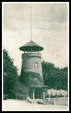
There were references too to Lewis’ lighthouse. It may have inspired some of the scenes in The Great Gatsby.
I’ve posted the photo below before. But I erroneously identified it as showing a big bash at Longshore. In fact — according to Webb — this is “a glittering summer party, complete with band, at the Lewis estate.” It certainly does look Gatsby-esque.
There’s also this fascinating map, drawn in 1921 by noted artist John Held.
Held included the lighthouse (right above the words “Long Island Sound”).
Check out the enormous boat sailing up the Saugatuck River, just south of downtown.
And — if you’re really eagle-eyed — you’ll notice that Held misspelled Bridge Street as “Brigde.”
What else stands out? Click “Comments” below.


I’ll get into trouble with this one I am sure.
The map is missing Gray’s Creek. While the point at Longshore is close to accurate the map is missing any indication of Ned Dimes Marina (Cedar Point to me) or the boat moorings at Longshore. Perhaps these were left out for space considerations. Here is where I’ll really get in trouble, the whole effect of the placement of the Lighthouse and Compo makes the area look like the state of Texas.
The Post Road was locally State Street, even then, as it was officially called when I grew up (though nobody really called it that. Also, was the Post Road bridge over the Saugatuck River the same as the current one?
Post Road bridge was much narrower. And for many years the obsolete toll station still stood there.
The pool where the party took place was still there when the town bought the property. I saw it a few time when I wandered around.
I noticed Compo Street
why, Ball Mountain of course (ref. previous debate as to whether it’s “Ball” or “Bald” Mountain)
I guess I never realized the origin of the Ford Road name until I saw this map.
That map reference is to the Kings Hwy bridge area, the first place where the Saugatuck is/was shallow enough (at low tide) to be forded on foot or horseback. But you are certainly correct, this is also where the British forded the river when they returned from their raid on Danbury, and Ford Road (where it starts off to the right where Clinton Ave encounters the river) is also where the Brits forded the river on the way up to Danbury. Hence Redcoat Road right across the way (used to be a bridge from Clinton Ave to Redcoat Rd back in the day)
I believe the origin of the name for Ford Road went back to the Revolutionary War. I missed that designation the first time I looked. I should have noticed it because I grew up not far from the Ford and we often waded in the river there and fished.
Yes, that was what my reference to “the Brits” was about
Yes…the placement of Compo beach is a bit off…it should be farther south….Dan…do you know if the marina area was there naturally or created for an anchorage? I’m wondering if that whole Owenoke area was swamp that was filled in for housing and the marina was dredged…..?
Owenoke was there with houses in 1943 when my grandmother moved there. I believe her house was built just before the turn of the century, 1898 I think I remember. She was at least the second resident of that home.
Bill – Old maps can tell the story, aerial phots do a great job too. Owenoke wasn’t so much swamp as it was a shorter strip of land, ending in a causeway of sorts, and then Hall Island made up the tip – the causeway has since been filled in to make Owenoke one continuous peninsula)
The 1934 aerial view shows this well:
http://magic.lib.uconn.edu/mash_up/aerial_index.html
Thanks and interesting. I can almost pick out the original spot of my grandmother’s house. In the 1950’s it was moved to the creek side. A long story not appropriate to take up space here. Many more houses have been added since this photo and even since my mother died in 1974.
wow there were two light houses? would be great to see some pictures and story on their demise!
I was wondering about Compo Street also. I noticed both a Black Smith Shopp and a Blacksmith Shoppe.
The map’s engraver has an interesting story: https://en.wikipedia.org/wiki/John_Held_Jr.
John Held Jr. made an enormous fortune in the 1920s and became a part of the high-society life that he depicted in his art. He had a fairly unpredictable and constantly shifting love life, as he was married four times. He married Myrtle Jennings in 1910. After a divorce, he married Ada Johnson in 1918. During the 1920s the couple adopted three children. He served as constable of Weston, Connecticut and ran for Congress as a democrat. – Chris Woods
Those were the days!
Across from the 17fh tee in the lagoon, there was a boat house that I was told was where the boats from Long with liquor during proabition would unload under cover. After all, Lewis didn’t have dry parties.
Intriguing that in the upper left it ways Avoid, wild savages in this direction. Guess it must have been pretty rough in Weston all the way into the 1900’s!
Too quick typing – I meant it “SAYS Avoid” not “ways Avoid”.