Yesterday’s “Friday Flashback” featured an aerial view of Westport, circa 1965. Readers remarked on long-lost icons like the Victorian house on Gorham Island, and long-lamented additions like the Wright Street building.
In case you missed it, here it is:
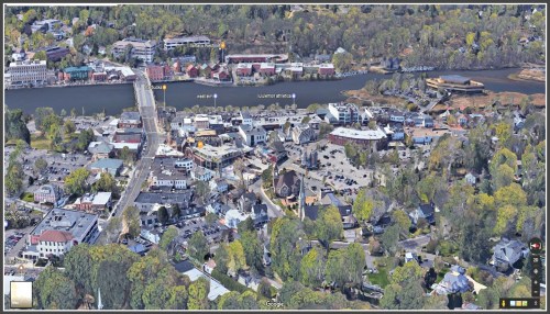
And now — if you’d like to compare — here’s what downtown looks like today.
Alert reader Glenn Payne sent along this Google Earth view.
You can tell it’s recent, because Bedford Square is under construction, and the Kemper-Gunn house has already been moved from Church Lane to Elm Street.
Click on or hover over both images to enlarge. They get bigger — just like downtown did.


Yesterday, my eye was drawn to what appears to be a white house located behind (and attached to) the building fronting the Post Road that is just beyond (west of) today’s Westport Pizzeria. That entire line of buildings fronting the north side of the Post Rd., from the former “Reading Room” and “Tack Room” to the former Westport Bank and Trust Building (now Patagonia) are completely altered today. I might add that today’s current tenants along that same strip are completely forgettable, at least to me. I was curious enough about the white house that I also checked today’s Google aerial view to see if it still existed in some form buried behind today’s facades. Nope!
ugly
first thing that strikes me is the lack of trees right downtown compared to ’65
That’s what I saw first as well.
Thanks. Love seeing the ’65 photo from “our” (baby boomer) heyday. Love all the old photos…..